Third amendment phase for Pispala local detailed plan begins
In accordance with national land use objectives, the objective of a local detailed plan for Pispala is to retain the significant cultural history of its built environment and to ensure controlled development of the area. The aim is to both safeguard and develop the remaining significant historic buildings and valuable areas as well as to direct infill construction in a way that matches the current environment and landscape.
Intended area development objectives include safeguarding of the area's recreational and natural values. For the nature and recreational areas on the shoreline, there is an intention to assign appropriate purpose and conservation markings.
Most of the properties in the area are privately owned. The nature and other public areas are owned by the City of Tampere. These include playing fields, a beach, piers, row boat storage and a varied network of outdoor routes.
The local detailed plan process in Pispala is divided into three phases. The first-phase plans became legally valid in 2017. The second-phase local detailed plan, under no. 8310, became legally valid in 2024 and plan no. 8309 was approved by the Committee for City Planning on 27 February 2026.
Green plateau on the esker’s southern slope
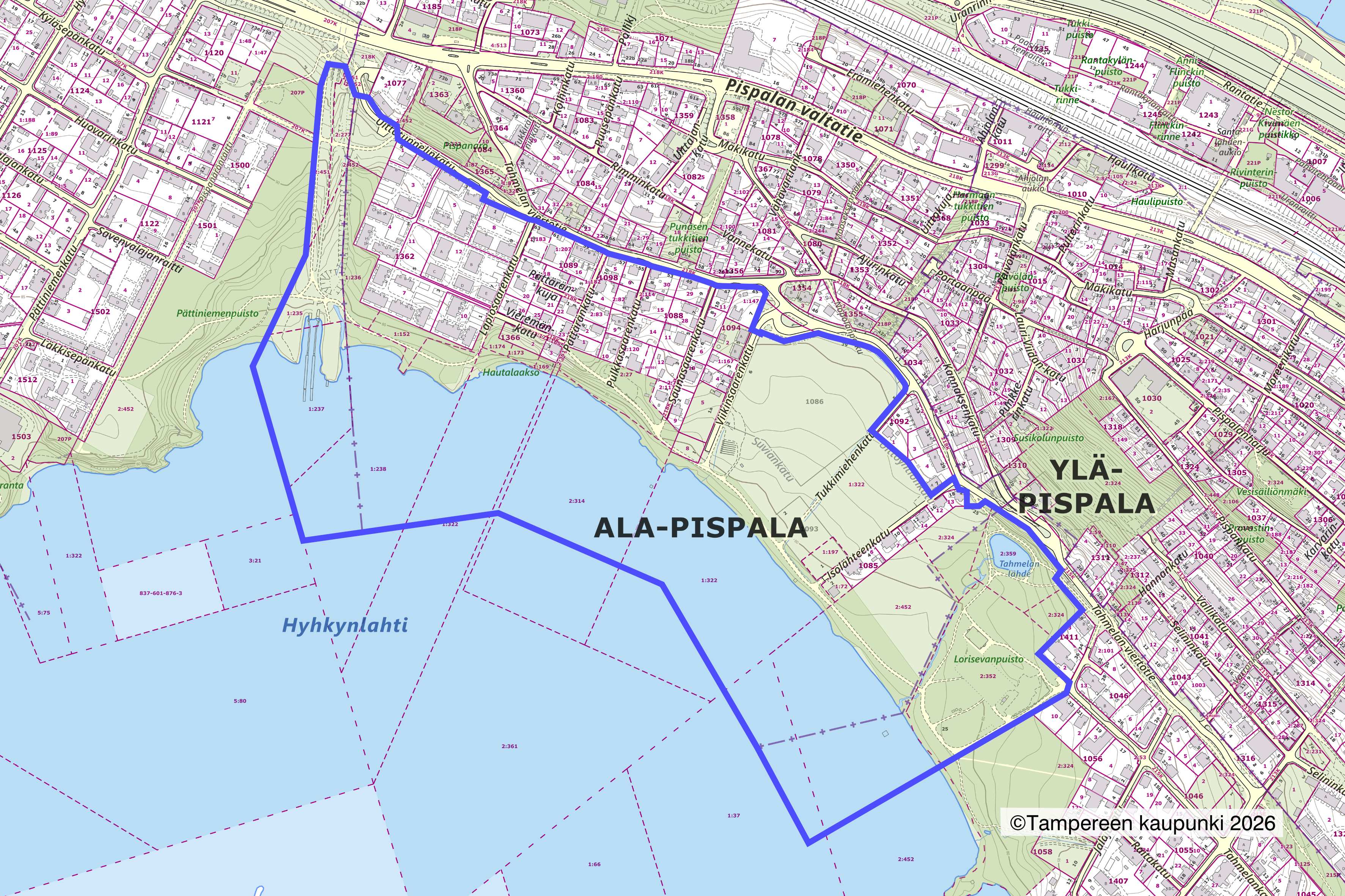
Pispala is a nationally valuable and renowned area, located 3 kilometres from the centre of Tampere on an esker between Näsijärvi and Pyhäjärvi. The area for which the local detailed plan is being amended is located on the plateau on the southern side of the esker, which lands in Pyhäjärvi. In the north, the area is bordered by Uittotunnelinkatu and Tahmelan viertotie, in the east by Tahmelan rantapolku and in the west by the 1960s timber tunnel line.
The plan area includes blocks of detached houses and valuable nature areas that include parcel farming areas and the Tahmela spring. The buildings in the area are small houses built in different periods and more spaciously than the rest of Pispala. The plan area is a part of a nationally significant built cultural heritage site (RKY) – Pispalanrinne.
There are also archaeological remains of a logging road in the area. The plan process for the Red logging Road, which was previously under a separate plan (no. 8824) will now continue in this plan (no. 8450).
Shore included in park network
In the master plan, the shore is a part of the central park network, which must be developed and maintained for accessibility and variety of functions. There is a recreational indication for the shore. Areas of significantly high natural value will be preserved and supported. The intention is that the shore remains an accessible recreational area for a large amount of people.
The area is in the heart of archaeological heritage. It is located in Pyhäjärvi’s development environment and the shore has been marked as a green link. There is an important groundwater area for water supply.
Progress in local detailed planning
The creation of a local detailed plan includes significant background studies and a versatile impact assessment. Earlier studies on the built cultural environment of Pispala and its nature as well as noise surveys will be used in the new planning process. The process includes updating these studies along preparing new studies, such as a study on the groundwater and the functional review of the public areas.
The material for the plan’s initial phase is available on the City of Tampere website along with an introductory video. Review of the material is also possible at the City of Tampere service point at Frenckellinaukio 2 B. Free-form, written comments on the participation and assessment plan can be submitted to the City Registry during the review period.
In the initial phase, the City Registry accepts comments on the participation and assessment plan (OAS) during the review period. After the feedback has been processed, the plan moves to the preparatory phase, after which the draft can be made available for public review, presentation and comments.
Subsequently, after the feedback and statements have been processed, planners will prepare the amendment proposal for public comments. In due course, the Committee for City Planning can submit the proposal for approval to the City Board and Council.


