New pedestrian guidance in the centres of Tampere and Hervanta
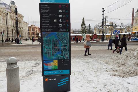
New pedestrian guidance has been installed to guide residents, commuters and tourists alike in the centres of Tampere and Hervanta. Maps of the area invite visitors to explore interesting places in the vicinity, and signposts guide pedestrians to their destination. Tens of thousands of pedestrians walk around the city centre every day, and there are thousands of them in Hervanta as well.
Maps of the area indicate important sites and the walking distances in metres and minutes
Pedestrian guidance includes large, board-like maps of the area and signposts. Both have a focus on the visual aspects. The map of the area contains information on nearby attractions, cultural sites, activities and transport services, and they are also marked with pictures or icons. The guidance may lead the pedestrian to Tampere Hall, theatres, libraries, university campuses, market squares, the stadiums of Ratina and Tammela, Tampere Central Deck, Särkänniemi, Tampere Market Hall and Stable Yards.
The distance is expressed both traditionally in metres and in minutes, and a circle on the map marks a 5-minute walking radius.
Signposts help you stay on the right track
Maps of the area have been placed in areas where people arrive, such as the railway station, Keskustori Central Square or the centre of Hervanta. The guidance is thus readily available to those getting off the bus, the train or the tram. There are maps of the area also in places with heavy pedestrian traffic. Guidance to sites is complemented with signposts that help you stay on the right track. Signposts have been placed in all the crossroads on the route.
Clear and safe routes
According to Transport Engineer Katja Seimelä, the clearest and safest walking routes have been selected for the guidance.
“The guidance to many sites recommends using the Hämeenkatu street because we want to guide pedestrians to the main street. Visitors to the Museum Centre Vapriikki will be guided from the Valssipadonraitti route via the Työnpuisto park underpass and not directly across the Satakunnankatu street via the Rongankatu street. In the centre of Hervanta, Hervantakeskus, the pedestrian is guided via the safest route to the University’s Hervanta campus via the Insinöörinkatu street,” Katja Seimelä explains.
Guidance invites people to walk from site to site
There are 13 maps of the area in the city centre and two in Hervanta. There are around 140 signposts and more than 300 signs. The background colour of the signs is black, so they can be distinguished from bicycling signs, for example. The visually impressive guidance is available in both Finnish and English.
High-quality pedestrian guidance helps residents, commuters and tourists enjoy the city without worry. Pedestrians can easily find their destination or visit interesting places spontaneously. The aim of the guidance is to encourage walking from site to site.
Tampere has received investment support for promoting walking and cycling, granted by Traficom.

Further information
Katja Seimelä
Transport EngineerPhone:
040 149 3684


