The centre of new Hiedanranta district is taking shape – local detailed plan preparation documents are available for viewing
The plan documents will also be presented to the public at the summer opening ceremony of Hiedanranta on Saturday 23 May 2026.
The local detailed plan creates blocks for new housing, parking, services and civil engineering maintenance, sections of the street network serving them, and green areas. Old buildings to be preserved are designated with protection markings in the plan.
Centre on the south side of Tehdas
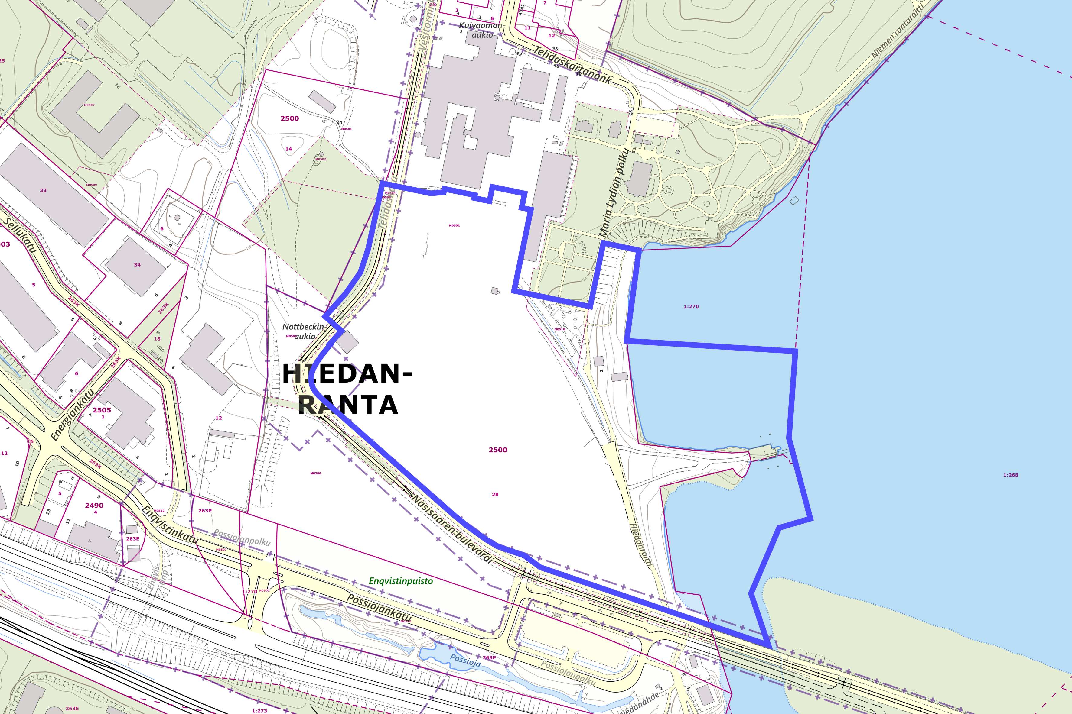
The planning area of Hiedanranta centre I is approx. 14.6 hectares in size. It is delimited by the tramway and Lake Näsijärvi on the south side of a large former factory building known as Hiedanrannan Tehdas. The area comprises a part of Lielahti district as well as some street and water areas and the district boundary.
The largest landowner is Hiedanrannan Kehitys Oy, a company fully owned by the City of Tampere. The city owns the ground under the tramway and the water area.
The planning area is practically devoid of trees, with the exception of those planted on the street with the tram line and trees on the lakeshore. The area has nature values, however, and its distinctive vegetation will be preserved and augmented. The grove on the lake shore will be preserved as an ecological corridor.
The main road and route for motor vehicles to Hiedanranta and the planning area lead from Lielahdenkatu in the west to Tehdaskartanonkatu. The traffic arrangements will be temporary and keep changing for a good while. In addition to public transport, the area is very easy to reach by walking and cycling along the main road and regional routes from the west, south, east and north alike.
Background to the plan and added detail
The planning of Hiedanranta was launched in 2016 with an international idea competition, based on which a general plan was drawn up for the area and adopted in 2020. Several interrelated local detailed plan projects have been completed and are under way in the area.
While elements of the general plan have been rearranged in the draft plan for Hiedanranta I due to more specific objectives and feasibility considerations, the local detailed plan mainly keeps to the solutions of the general plan. Rather than comprising the 13 small blocks of the general plan, the framework of the 2026 plan consists of seven large blocks with large green courtyards.
The area’s feeder street, a business street and a green street come together in the central Hiedanaukio square. Parking will be centralised to two parking facilities with around 600 spaces located in city blocks close to the residents. The area’s feeder street, business street and strong green street come together in the central Hiedanaukio square. In the general plan of 2020, parking was located further south and on the south side of the tramway, where no amendment to the local detailed plan is yet pending.
Housing and business premises
The urban structure of Hiedanranta centre will consist of seven closed-in blocks and the associated streets, squares and parks. The buildings will have from four to twelve storeys, and their roof shapes will be varied.
The large blocks will also allow for spacious and green courtyards. In addition to housing, common facilities and business premises will be located in the blocks. Housing will account for some 155,000 m2 of floor area, which theoretically means more than 3,000 residents. Approx. 2,500 square metres of floor area will be allocated to commercial services.
The local detailed plan allocates building rights amounting to 162,000 square metres of floor area, of which the blocks will account for approx. 6.1 hectares. There will be around 2.5 hectares of parks and protected green areas, along with approx. 4.2 hectares of street area and 2.2 hectares of Lake Näsijärvi water area.
Commercial services
The pedestrianised section extending from the future tramway stop and ending at Hiedanaukio will be named Urbanuksenkatu. This name has a double meaning: it refers to Urbanus Henriksson, who lived here in the 16th and 17th centuries, in addition to which Hiedanranta is set to be a particularly urban environment.
The ground floor business premises will be centralised around the tramway stop and along Urbanuksenkatu. Facilities with windows and functions that enliven the cityscape must be placed on the building's ground floors. The aim is to create a welcoming and interesting urban space from a pedestrian's viewpoint. The most significant part of the commercial services and jobs in Hiedanranta centre will be located on the south side of the tramway close by the tram stop and bus terminal, in the area of a local detailed plan to be drafted later.
Lydiankatu, which will be built as a green area, will connect Nottbeckinaukio square to Hiedanranta lakeshore park in the east-west direction. The two parking facilities will be located on Patruunankatu, which runs from north to south.
Protected buildings and green areas
The locomotive shed Ronttila, the Gatekeeper’s house and the façades of Pumppaamo will be preserved. The above-ground and subterranean structures of Möljä, or the platform area, will have a protection marking in the plan. The structures reminiscent of the area's industrial history will be preserved. The old buildings will remain part of the renewing area, and activities suitable for the cultural environment can be placed in them.
Hiedanranta centre will be connected to the future Hiedanranta lakeshore park and the central park, which are part of a wider network of green corridors and recreational areas.
The extensive green area on the lake will be named Hiedanranta shore park, while the area with port operations will be known as Hiedanranta harbour, in keeping with established practices in the different areas of the city.
Along Hiedanraitti on the shore of Lake Näsijärvi, residential buildings with lake views, ground floor terraces and roof terraces on the top floor can be built.
A modern look steeped in history
Bricks laid on site or wood must be used as the main façade material of residential buildings. The objective of the material selections is achieving a rugged but modern architectural look that draws on the industrial history of the area.
The general colour scheme in Hiedanranta centre will consist of earthy shades of red and brown inspired by the factory milieu. As an exception, off-white and ochre will be used in higher individual houses along Näsisaari boulevard, or the tramway street.
On residential streets, a smaller scale and more varied look will be sought. Different tones must be used in the façades of residential buildings on adjacent plots.
A new regional centre in the west
The plan is that Hiedanranta-Lielahti will be an urban centre in western Tampere with not only local but also regional significance. Approx. 3,000 new residents and the centralised urban structure will create good preconditions for providing services and ensure the feasibility of commercial and cultural services. The long-term goal is at least 18,500 new residents in the area.
The city intends to turn Hiedanranta into a sustainable district that offers a high-quality working, living and service environment while preserving and drawing on the history and cultural heritage of the area, innovative solutions and an excellent location along the tramway and on the shores of Lake Näsijärvi.
The preparation documents of local detailed plan Hiedanranta centre I, in other words the revised participation and assessment plan, including the draft plan, plan description and information material as well as the building method guideline will be available from 30 April till 28 May 2026. While the documents are available for public view, comments can be submitted to the city’s Registry.
The illustration shows buildings that could be constructed in the area in keeping with the draft local detailed plan.
Illustration of the southern end of the street with commercial premises known as Urbanuksenkatu in Hiedanranta centre, from the tram line towards Hiedanaukio. Illustration of the applicant’s reference plan. Image: Hiedanrannan Kehitys Oy / Oopeaa Office for Peripheral Architecture


